





DRB Hears Revised Plans For Sanborn Covered Bridge Restoration
Paul Hayes phayes@littletonrecord.com Staff Writer Nov 10, 2025 Updated Nov 10, 2025


NOTE: The original version of this story incorrectly reported the river channel under the bridge will be widened. No changes will be made to the river channel.
LYNDON — The Development Review Board on Thursday reviewed updated plans to renovate the Sanborn Covered Bridge, which was nearly destroyed in last summer’s flooding.
The board approved an earlier version of the project in May 2024, but after the catastrophic July 2024 flood, engineers revised the design to raise the bridge higher and strengthen its abutments. The new plan would elevate the bridge above the 500-year flood level with an additional foot of freeboard, helping protect it and nearby infrastructure during future floods.
Presenting the revisions, Select Board Chair Chris Thompson said the updated design improves flood mitigation by lifting the bridge.
“The town is presenting to you tonight a better project than the one that your legislative body approved unanimously about a year and a half ago,” Thompson told the board. “This version of the design provides greater protection for not only the bridge itself, but also for the community, by increasing flood resilience in the area around the bridge.”
Because the revisions represent a material change, the project requires new site plan approval and a conditional use permit to rebuild and replace the bridge and abutments within the special flood hazard overlay district. The board has 45 days to issue a decision.
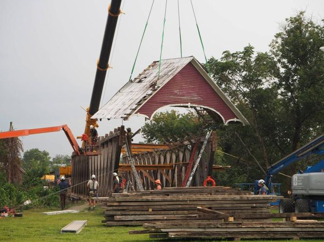
Thompson said the redesign was driven by repeated flooding in recent years, including the July 2024 storm, when the swollen Passumpsic River bowed the structure, broke one abutment, and nearly swept the bridge away. The bridge was later disassembled and removed to prevent further damage until restoration could begin.
“The catastrophic flooding that hit Lyndon really made us reconsider the design,” he said.
The original 2024 plans would have raised the bridge about 2.5 feet to meet the town’s bylaw requirement of being above the 100-year flood level. The new design raises it four feet — one foot above the 500-year flood level.
The waterway opening beneath the bridge would also increase from 190 to 278 square feet, about 50 percent larger than the previous plan.
“It’s a very substantial increase,” Thompson said. “Unfortunately, we don’t know what’s coming, but we know what’s hit us recently. All efforts were made to protect the bridge and also protect the area around the bridge, causing the least amount of impact on the site itself and to the community at large.”
Pedestrian access will also change. Instead of ramps on both ends, the bridge will feature steps at the north entrance and an ADA-accessible switchback ramp on the south side. Bollards will be installed to block motorized vehicles.
If approved, the project would go out to bid this winter, with construction expected to begin in the spring and take about a year to complete, depending on funding and bid results. The project’s $2.2 million budget, set two years ago, has not been updated to reflect inflation, design changes, or flood-related revisions. Thompson told the Select Board in July that if bids come in higher than expected, the town may need to scale back or delay construction.
Restoration of the 156-year-old bridge began more than two years ago. Although the project was initially expected to be funded primarily through grants, rising costs have officials concerned about potential impacts on taxpayers.
During Thursday’s meeting, Zoning Administrator Jon Prue asked whether easements and grant restrictions could limit future development around the bridge.
Original plans called for a small park on a town-owned parcel at the south side of the bridge. Thompson said grant conditions would allow construction of a parking area but would likely prohibit more extensive development.
“[The grants] would allow [parking] because parking allows people to access the bridge that those grant funds are going to rehabilitate,” he said. “But it’s not going to allow the town to put in swing sets and blow this up into a major park. Some of the grantors specified that the site would have minimal development.”
“So those easements would keep a park from being able to go there?” Prue asked.
“I guess it would depend on what they determine is allowed there, and then we would be able to go up to their limits. But if it’s a legal easement, then we have to respect that as a town,” Thompson replied.
“I think the town looks at it, and I think the funders look at it in this way — that this new design protects our investment in the bridge and theirs as well,” he added. “We’re not making changes in the bridge that reduce its historical significance. We’re trying to protect this for generations to come, and we wouldn’t do something in the design, and they wouldn’t allow something in the design, to jeopardize that.”
The redesign, requested by the town’s Hazard Mitigation Committee, aims to improve flood flow and public safety. The committee voted last August to preserve and elevate the bridge rather than remove it entirely as recommended by consultants at SLR International.
Although the town did not follow that recommendation, engineers used SLR’s flood modeling data to inform the revised design. The renovation includes structural repairs, rebuilt abutments, and other flood mitigation measures. The bridge would be raised from nine inches below the 100-year flood elevation to one foot above last July’s flood levels.
Built in 1869 and moved to its current site over the Passumpsic River in 1960, the Sanborn Covered Bridge was purchased by the town in 2022 along with the two-acre parcel on the south end.
Editors note: Information reprinted with permission from the Caledonian Record Publishing Company, Inc.
